
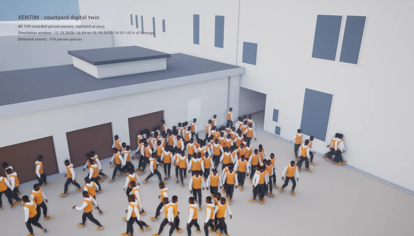
- Site: a residential courtyard in Poznan, about 270 m², garages on one side, a passage to the street on the other
- Camera: one existing camera, mounted 8.15 m above the ground, 1920x1080
- Data: 45 hours of footage, 13 to 15 October 2026: 159 person passes, 26 cars, 6 bicycles, each tracked by Xentim
- Result: a measured digital twin of the courtyard, a coverage map in square metres and a replay of every recorded walk from the real camera position
Why we did it
Xentim already turns camera footage into events: who passed, when, along which path, at what pace. That data usually ends up as alerts and search results. We wanted to find out what else it can tell a site owner.
The idea is simple. If you know exactly where a camera hangs and what it sees, every track it records becomes a real path on the ground, in metres and seconds. Put enough of those paths together and you see how a place is actually used, not how it was designed to be used. From there you can play out scenarios: how people would leave the yard in an emergency, where a wheelchair or a pram gets stuck, where a bench, a bike rack or a bin would help and where it would be in the way.
We tested this on the one site we can measure freely: our own courtyard.
The challenge
- No plans. There was no site plan, no drawing and no 3D scan of the courtyard. Only the camera and a tape measure.
- One camera, one angle. One camera, looking down from a window high above the yard. Whatever it does not see, we cannot track.
- Confidence. On the monitor the yard looked fully covered. We did not know how much of it really was, or how sharp the picture was where it mattered.
What we wanted to measure
- How much of the courtyard the camera really sees, in square metres
- How sharp the image is across the ground, against the DORI levels of IEC 62676-4
- Where people actually walk, at what pace and at what times of day
- Whether recorded walks can be replayed faithfully from the camera position
What we did
1. Measured the site without plans
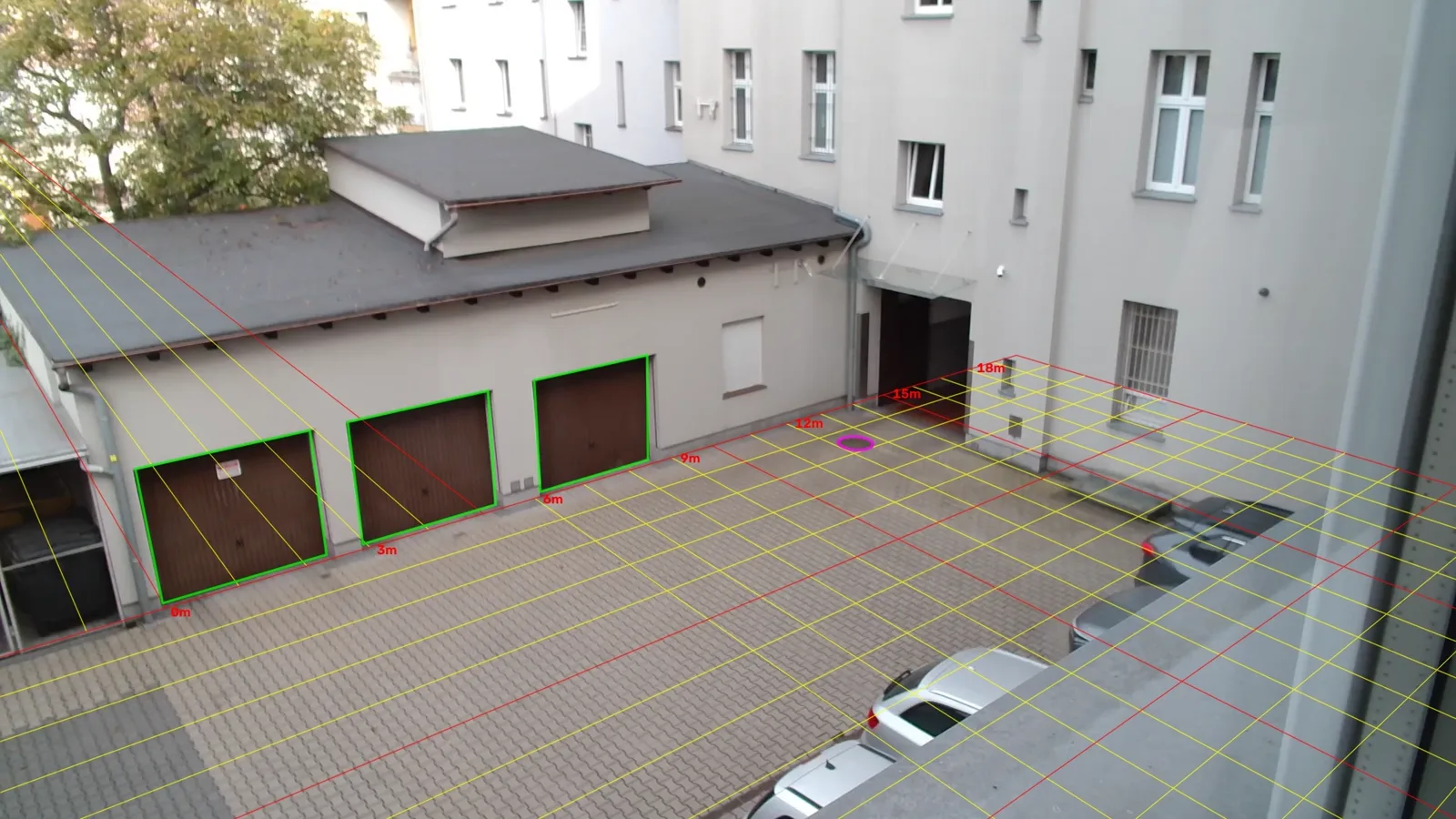
We took a handful of tape measurements of things the camera can see: the three garage doors, a window shutter and a manhole cover. From those alone we worked out where the camera hangs and how it looks at the yard: 8.15 m above the ground, 15.2 m from the garage wall, tilted 21° down, with a 70° field of view. Measured points land within about 2 pixels of where the model expects them. Every pixel on the ground now has a position in centimetres, from about 1 cm per pixel close to the camera to under 3 cm at the far end.
Our first attempt used a parked car as the ruler instead. It looked fine until we checked the pace of people walking: they came out more than twice too fast. Checking against walking pace caught the error. Measuring fixed things on site fixed it.
2. Rebuilt the courtyard as a digital twin
With the camera pinned down, we built a 1:1 model of the courtyard and placed a virtual camera exactly where the real one hangs. In the twin every patch of ground can be checked: is it in the frame, is it hidden behind something, how many pixels per metre does it get.
3. Replayed every recorded walk
Each of the 159 person tracks became a walking figure in the twin, on its real path, at its real pace, seen from the real camera position. Side by side with the original footage, one pass looks like this:
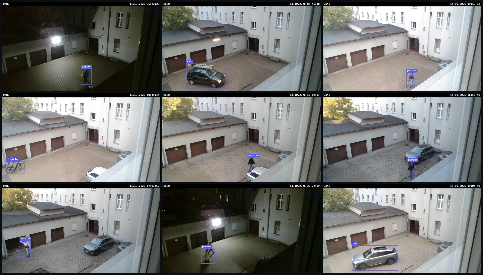
These are the real events the tracks came from. Nine of them, by day and by night:
All 159 passes at once:
Results
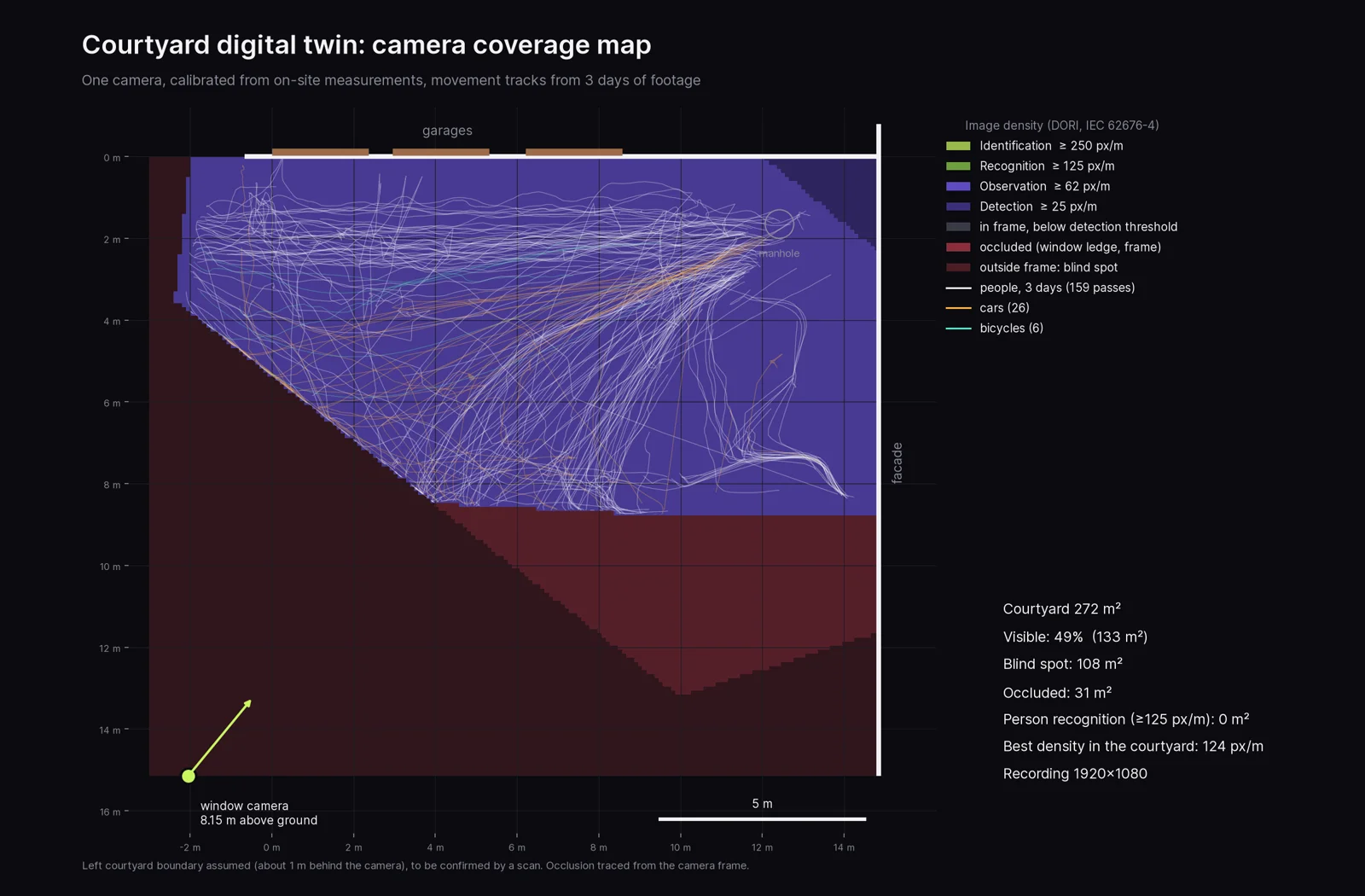
- Visible: 49% of the courtyard, 133 m²
- Outside the frame: 108 m², mostly directly below the camera
- Hidden behind a window ledge: 31 m², exactly where cars park
- Good enough to recognise a person: 0 m². Recognition starts at 125 px/m; the sharpest spot in the yard gets 124
- Where people walk: 63% of the walking time we observed is within 4 m of the garage wall, and 83 of 159 passes cross the area by the passage to the street
- When: two peaks, 9:00 to 10:00 (29 passes) and 15:00 to 17:00 (34 passes)
- Pace: a median of 4.6 km/h, the number an evacuation scenario starts from
What we learned
- A monitor is not a measurement. The yard looked covered. Half of it was not, and nowhere was the picture sharp enough to recognise a person.
- You do not need plans to start. A few measurements of things the camera can see were enough to turn one camera into a measuring instrument. A scan would sharpen the edges, but it is not a precondition.
- One camera already says a lot about movement. Even with half the yard out of view, the tracks show a clear main route, clear peak hours and a real walking pace.
- The blind spot is also data. The replay stays empty where the camera sees nothing. That is the first thing to fix before any scenario is trusted.
What this makes possible
With paths, pace and timing from real footage, the twin becomes a place to test changes before making them:
- Evacuation: how long it takes to clear the yard at the 9:00 peak, and what happens when a car blocks the passage
- Accessibility: where a wheelchair or a pram meets a kerb, a step or a parked car on the route people actually use
- Small architecture: where a bench, a bike rack, bins or planters fit without cutting across the main route
- Obstacles and aids: what to move, what to remove, where a ramp or a light would help
- Cameras: where a second camera or a different lens would close the blind spot, checked before buying anything
If you could see every path people take across your site, what would you change first?
Questions and answers
What is a digital twin of a site?
A 1:1 model of the place with every camera positioned as installed, so that what each camera sees can be measured in square metres and pixels per metre, and recorded movement can be replayed on real paths.
Do you need site plans or a 3D scan?
No. A few tape measurements of things visible to the camera are enough to start. A scan improves accuracy at the edges of the site.
What does DORI mean?
Four levels of image density from the IEC 62676-4 standard: detection (25 px/m), observation (62 px/m), recognition (125 px/m) and identification (250 px/m).
Does the replay show who the people were?
No. The replay uses movement tracks only, position over time. The figures are generic, and the original footage shown here is blurred.
Source: IEC 62676-4, Video surveillance systems for use in security applications, Part 4: Application guidelines (DORI levels). All other numbers come from our own measurements and recordings in the courtyard, 13 to 15 October 2026.